Agrarian History
Land Reclamation in the Pianura Padana

The word bonifica carries a specific technical meaning in Italian — the organised improvement of unhealthy or unproductive land, most commonly by drainage — but its application to the Po Valley describes something more complicated than any single engineering project. Bonifica in the Pianura Padana was a process that unfolded across several centuries, shaped by changing technologies, shifting political arrangements and evolving ideas about the relationship between land, water and agricultural production.
The Landscape Before Systematic Drainage
Historical sources, cartographic records and landscape archaeology together allow a partial reconstruction of the Po Plain before the great drainage campaigns of the nineteenth century. Much of the lower plain — the territory east of a line roughly from Piacenza to Rimini — was occupied by shallow lakes, seasonal wetlands, reed beds and river floodplains. The Valli di Comacchio, a complex of coastal lagoons and brackish marshes south of the Po delta, extended far further inland than they do today.
The 1787 map of the Po delta preserved in the Ferrara civic archive illustrates the extent of this pre-reclamation landscape. The delta channels are shown as multiple braided distributaries crossing a flat territory of marshes and islands. Roads appear only along the embankments and on the highest ground; most movement was by boat.
This landscape was not uninhabited or economically inactive. Fishing, wildfowling, salt extraction and reed-cutting provided livelihoods in the wetland zones. But the agricultural potential of the land was largely unrealised, and the wetlands were associated with malaria — a disease that severely constrained settlement and labour availability across the region until well into the twentieth century.
Early Modern Reclamation Initiatives
The Este dukes, who controlled Ferrara from the thirteenth to the late sixteenth century, invested substantially in drainage and agricultural improvement within their territory. Ducal engineers constructed embankments along the Po branches, dug initial collector channels and organised the distribution of reclaimed land to colonist farmers through a system of long-term leases. This early modern bonifica was limited in scale compared to what followed, but it established the institutional and cartographic infrastructure that later engineers and administrators inherited.
After the Este were expelled in 1598 and Ferrara passed to the Papal States, the momentum of reclamation slowed. Papal governance of the region was generally less intensive than ducal administration had been, and the consortia of landowners who managed drainage infrastructure lacked both the capital and the political authority to undertake major new works. The landscape condition deteriorated across much of the seventeenth and eighteenth centuries.
Unification and the First National Drainage Laws
The creation of the unified Italian state in 1861 opened a new chapter in the history of reclamation. The new government inherited a patchwork of local drainage arrangements, many in poor condition, and faced the question of how to structure public investment in hydraulic infrastructure. The answer came through a series of drainage laws beginning with the Baccarini Law of 1882.
The Baccarini Law classified reclamation works by their scale and public importance. First-category works — those affecting large areas or bearing on public health — were to be funded largely by the state. Second-category works were the responsibility of local consortia with partial state subsidy. This classification system created clear incentives for consortia to seek first-category designation and channelled national investment toward the most extensive drainage projects.
Key Legislation
- 1882
- Baccarini Law — first national classification of drainage works; state funding for first-category reclamation
- 1900
- Giolitti-era supplements extending subsidies to agricultural improvement works alongside drainage
- 1923
- Royal Decree 3267 — land improvement frameworks revised and expanded
- 1933
- Mussolini Decree 215 — bonifica integrale extended to cover hydraulic, agricultural and social transformation simultaneously
The Bonifica Integrale Programme
The phrase bonifica integrale — integral reclamation — became the organising concept for Italian land improvement policy in the 1920s and 1930s. Its meaning was deliberately broad: reclamation was no longer understood merely as the removal of water but as a comprehensive transformation of territory, combining drainage with road construction, land redistribution, rural colonisation and the elimination of malaria.
The 1933 legislation gave the Ministry of Agriculture authority to approve reclamation plans that incorporated all of these elements and to provide state funding for their execution. In the Po Valley, several major projects were advanced under this framework, completing drainage works that had been planned but not executed under earlier legislation and extending cultivation into areas that had remained wetland throughout the preceding decades.
The social dimension of bonifica integrale was expressed most clearly in the settlement programmes attached to some projects. New farmhouses — case coloniche — were built on reclaimed land according to standardised plans and distributed to farming families brought in as colonists. Villages with their own civic infrastructure were established in areas that had previously had no permanent settlement. This aspect of the programme was most visible in the Agro Pontino south of Rome, but elements of the same approach were applied in the Po delta and the lower Ferrara plain.
The Po Delta Reclamation
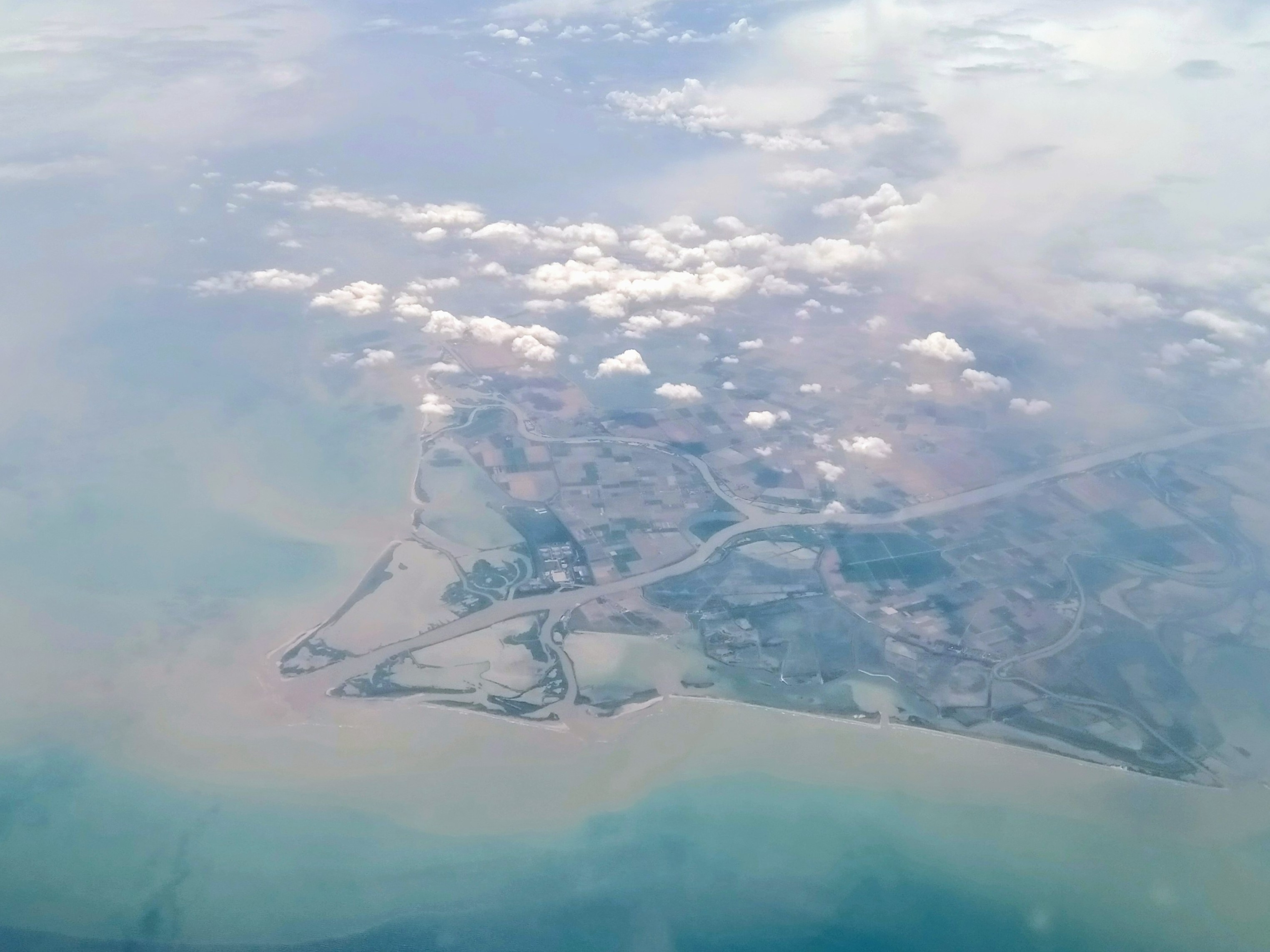
The Po delta itself — the territory between the main Po channel and the coast — was the subject of a sustained reclamation effort that ran from the late nineteenth century through the mid-twentieth. The delta is geologically young and topographically dynamic: new land is continually being formed by river sediment at the mouth while older surfaces subside as sediment compacts. This instability made engineering in the delta particularly demanding.
The principal interventions involved embanking the main distributary channels of the Po, draining the inter-channel lowlands through a network of canals and pumping stations, and constructing barriers to prevent saltwater intrusion into the reclaimed fields. The resulting landscape is geometrically ordered, with straight channels, rectangular field patterns and roads running on top of former embankments — a pattern clearly visible in aerial photographs and satellite imagery.
Land Tenure and Social History
Reclamation in the Po Valley was never politically neutral. The allocation of newly drained land, the terms on which it was cultivated and the burden of drainage costs were all subjects of persistent social conflict. Landowners who stood to gain from reclamation typically held more political influence than the tenant farmers and labourers who would work the improved land under conditions set by others.
The large landed estates — latifondi — that dominated parts of the lower Po Plain controlled substantial political resources and were able to shape the terms of reclamation to their advantage. Tenant contract arrangements, particularly the mezzadria share-cropping system, concentrated the risks of agricultural investment on cultivators while allowing landlords to benefit from state-subsidised improvements without bearing the full cost of management.
From the late nineteenth century onward, agricultural labour organisation in the Po Valley — the bracciante day-labourers who did the drainage excavation and fieldwork — was among the most politically active in Italy. The conditions of land reclamation, including the use of outside labour brought in during construction and the subsequent denial of permanent employment to local workers, were recurring sources of conflict.
Post-War Reconstruction and Land Reform
The immediate post-war period brought renewed attention to the condition of reclaimed land in the Po Plain. Wartime damage to embankments and drainage infrastructure had allowed large areas to flood again. Reconstruction of the drainage system was a priority for both Italian and Allied authorities administering relief programmes.
Land reform legislation in 1950 broke up some of the large estates and redistributed land to small farmers. In the reclaimed areas of Ferrara and the delta, this created a more fragmented ownership pattern that complicated the management of shared drainage infrastructure, since the consortia now had to negotiate with a larger number of smaller landowners.
The Reclaimed Landscape as Heritage
Recognition of the bonifica landscape as a cultural heritage asset has grown since the 1990s. The UNESCO World Heritage listing of the Ferrara city centre in 1995, extended to include the Po Delta regional park in 1999, drew international attention to the historically modified landscape of the lower Po Plain. The listing recognised the interaction of natural and managed landscape processes over several centuries rather than treating the canal network and settlement pattern as purely engineered artefacts.
For researchers in landscape history, agricultural history and historical hydrology, the Po Valley bonifica landscape offers a well-documented case study in the long-term modification of a major river plain through organised human intervention. The documentary record — including the archives of the bonifica consortia, municipal engineering records and the extensive photographic documentation assembled during the major twentieth-century campaigns — is substantial and has been only partially exploited by historians.